")

57 villages in the path of Bike Odyssey 2014!

Quaint, mountain villages of unique natural beauty and historical significance will be among the places that the toughest mountain bike race will cross along the mountain range of Pindos.
Some of the villages and settlements along Bike Odyssey 2014 route:
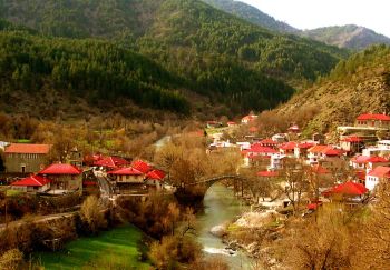
Smixi
Smixi is a mountainous village in the prefecture of Grevena, derived from the union (smixi means union in greek) of Pinakades village and Biga village, whose inhabitants wanted to escape malaria. It is built at an altitude of 1,220 meters on the hillside of Smolikas Mountain and is one of the most mountainous villages of Greece.
Ιts population is 750 residents. Due to its proximity to the ski resort of Vasilitsa it has become an important winter resort in the region. It located 38 km from Grevena.
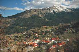
Avdella
Avdella is classified as a rural mountain village, built at an altitude of 1300m. It is located at the western end of the prefecture of Grevena, close to the borders with the prefecture of Ioannina. It abstains from Grevena, 43 km., to the Southwest. The village is built on the eastern slopes of Northern Pindos, in a wooded area at the boundaries of the National Park of Valia Calda, and the high altitude is making it one of the most mountainous villages of Greece.
Before 1800, the village was situated in the "Fantines" region, but the residents, mostly large families of Vlach shepherds moved to the current position due to better climate. The people of Avdella actively participated in the Greek Revolution of 1821 and the Macedonian Struggle with major Macedonian Leaders Verros Zisis and Ioannis Chatzigiannis.
Milia
Milia is one of the most beautiful villages of Epirus. Located at an altitude of 1250 meters above sea, on the mountains of Pindos. The village belongs to the prefecture of Ioannina, in particular occupies the northeastern part of the countyside, just 65 km from Ioannina.
It is one of the traditional villages of Pindos, with a permanent population of 450 inhabitants. Embraced from the mountains Livadi, Mavrovouni, Tsapouli and Antichasia. Located between Metsovo (prefecture of Ioannina), the Malakasio, Palia Koutsoufliani (Trikala) and Krania (Grevena) – in between the boundaries of Epirus, Thessaly and Western Macedonia.
Kastania
Kastania is a beautiful village of Pindos located at an altitude of 850 meters. The area is full of chestnuts walnuts, apple trees, hazelnuts, beeches, firs and pines. Near the village there are water sources named 'Stinas' (in a place called Goura) and water sources in 'Bouros'. Close to village you can find a forest at Kinigos mountain (1,845 m), the peaks Krounes(1,239 m), Morava (1930m) and Chioli at the southwest (1.970m.). In the village there are traditional tavernas and cafes, the area Goura, the chapel of St. Athanasius and the monastery of St. Nicholas.
Amarando
 The village Amarandos is located at an altitude of 950 meters of Pindos Mountains. A place with extreme beauty protected by the European Union as Natura 2000. The Amaranth is a mountain resort, built in firs. Far from Trikala 58 km and from Kalambaka 37 km. Located south of the municipality, between altitudes 780 - 1020m.
Palaiochori
Paleohori is mountainous farming village in the prefecture of Ioannina. It is built at an altitude of 650 to 1050 meters on the slopes of Tzoumerka mountains. Paleohori is built on two opposite sides of ridge Kirkou and Tsarkou (2.048 m) of Mt Lakmos and (1.333 m) Lapaton on the other. It is crossed by two streams. Locals are friendly people and the area organiozes several festivals.
Aidona
Aidona is a small village situated at an altitude of 850 meters. The paved square, the stone church of Aghia Paraskevi with its ornate steeple, welcome the impressed the visitor. A special attraction of the village is the old elm, at the square that has been declared as a Natural Monument. The beautiful environment, traditional fountains and the warm hospitality of the inhabitants are some of the features that attract many visitors.
Chrysomilia
Pertoúli
At an altitude of 1090 meters and a distance of 50 km from Trikala, right after Elati village, we come across the amphitheatrically built, village Pertoúli. With one of the most beautiful and well preserved fir forests in Greece and its ski resort, Pertouli is one of the most prominent winter destinations. The picturesque stone houses with red or stone roofs are a feature of the village.
Kallithea
Psarro
Isiomata
Metamorphosi
The village Metamorphosis is positioned in the center of Karditsa regional unit. Is a village in the municipality of "Palama" and is built trough the Thessaly plain. Residents of the village are approximately 300. The vast majority of residents are engaged in agriculture and especially the cotton crop, and less on farming. Typical location of the village is the church of the Metamorphsis, where a feast is held every year during the weekend 5-6 August.
Lagadi
Anthiro
Anthiro is a mountain village in the western part of the Karditsa regional unit, Greece. Anthiro is the seat of the municipality of Argithea. Anthiro had a population of 498 in 2001. Anthiro is located 20 km southwest of Mouzaki, 40 km west of Karditsa, and 19 km southwest of Pyli.
Its residents are based in agriculture which includes honey production. There is a museum in the village. Near the village are the Korakos bridge, built in the 12th century, and the Kleftovrysi and Stavro bridges.
Potamia
Kritsari
Argithea
Argithea lies in the southern part of Pindu. The area consists of 24 small villages with 400 inhabitants in total. Many monuments from ancient time were discovered recently such as ancient ruins, parts of statues and ancient cemeteries etc. There were also found a looted and destroyed tomb, headstone inscriptions and other parts. This is one of the most important archaeological sites of the ancient city of Athamania. Finally, an arched bridge is preserved.
Livadia
Livadia is a village in the prefecture of Karditsa and belongs to the municipality Mouzaki. It consists of a few houses built on the mountain slopes, among meadows and old growth trees that surround the local river. The altitude is over three hundred meters. It is a few kilometers away from the Lake 'Plastira'. Local residents are engaged in agriculture and animal husbandry.
Polydroso
Argiraika
Petrilio
This is one of the best resorts in the area with picturesque houses and unique churches. Located in the center of the northern Agrafa Mountains, at 1100m altitude, between two towering mountains, Voutsikaki and Delidimi. The landscape is I astonishing and evocative, it is sure to amaze you. To the east of the village rises the imposing Voutsikaki (2,154), just below the top of which Petriliotis River springs. The river crosses the village and ends to to Achelous river.
To the west and north Karava Mountain rises (2,184 m), while all around, one encounters many other mountains. The international path E4 (for climbers and hikers) passes through Petrilo and one can admire the dreamy fir forest.
Charis is a mountainous village of Karditsa. It is located at an altitude of 1,100 meters on the slopes of Agrafa Mountains and is one of the most mountainous settlements of Thessaly region.
Koustesa
Vrangiana
Remote village that flourished during the Ottoman rule with its famous school where the great teacher Eugenios Giannoulis taught in the church of Agia Paraskevi, which was built in about 1645. Here is the famous fountain "Fontana". Has 98 residents and is 120 km from Karpenisi city. It is built at an altitude of 1080m.
Dendro
Tridendro
Agrafa
Agrafa is one of the most well-known geographical and historical areas of our country and is an extension of the southern side of the mountain range of Pindos. Agrafa region consists of several peaks, some of which belong in the highest mountains of Greece. Agrafa mountains are crossed by two rivers: Tavropos or Megdovas and Agrafiotis. Vast, beautiful forests cover the area. There are almost all kinds of trees. The landscape is amazing and the view from the varius vilages of the region is unique.
Kamaria
Kamaria is small stockbreeding village of Evritania prefecture, built on the slopes of Agrafa at an altitude of 1470 meters. It is the highest village of Evritania and one of the most mountainous in Greece. Located east of the village of Agrafa, among the tops Karnopi, Svoni and Morforachi.
Neraida
Settlement of Evritania located northeast of the village of Unwritten, built at an altitude of 820 meters.
Kleisto
Village in the prefecture of Evritania. At 780m. altitude, 485 inhabitants, located 53 km from the city. Rich in Christian and Byzantine treasures.
Mesochori
Vracha
Village at an altitude of 900m with 169 residents. Historical village, where at "Koukia" location a hsitorical battle took place in when Greeks fought the Ottoman rule. The church of Christ dates back to 1660 and are preserved in this great icons and frescoes. It is 45 km from Karpenisi.
Chohlia
Built on 930m altitude. Probably the location of Ancient Oihalia, the ancient capital of Evritania. Here lies an ancient settlement where a large quantity of ancient artifacts, graves and grave goods was found as along with a statuette of the god Dionysus, who represents the god of joy crowned with ivy.
Petralona
Petralona is a village of Evritania, built in the northeastern part of the county on the border with the region of Karditsa. Until 1955 it was named Saika. The village is built at an altitude of 900 meters under the mountain tops Svoni, Pente Pirgoi, Flytzani.
Agia Triada
Located on the north side of Tymfristos (Velouchi) mountain at an altitude of about 770 meters. The area attracts tourists, since it is very close to the center Velouhi (ski resort).
The village has a glorious history. The village many old well-kept homes are well preserved and give a unique picture. The main springs of river Megdova are located here.
Karpenisi
Myriki
Myriki is a mountainous village in the prefecture Evritania. It is built in a dense pine forest at an altitude of 1,120 meters on the slopes of Tymfristos. The village was famous for the local traditional costumes and the excellent forage products. East of the village, you can visit the chapel of Prophet Elias and enjoy the view from the point while you spend moments of relaxation and rest in a specially designed recreation area in the courtyard of the chapel.
Among the trees, you can relax and breathe in the clean air while you enjoy the magic of the landscape offers in Miriki.
Krikello
Krikello located in Southeast Evritania. It is built at an altitude of 1,120 meters on the eastern side of Mount Kaliakouda near the sources of Krikellopotamos river(or Krikellioti), and is one of the most mountainous villages in Greece. Once you enter the village we see seven water sources that run from the stone mugs. The cathedral church, Agios Nikolaos is the newest monument located in the central square of the village among dense trees.
Ampelia
-The settlement Ampelia in the area Domianoi, located east, about five minutes from the village Domianoi. Has no permanent residents just some visitors from near villages that take care of vineyards and some domesticated animals. There is the picturesque church of St. John (1852), a place for relaxation and visual pleasure.
Domnista
Stavloi
Stavloi is a mountainous village in the prefecture Evritania. It is built at an altitude of 1,230 meters on Mount Oksia which is the ending Vardoussia mountain range. Stavloi is one of the most mountainous villages in Greece. According to tradition and archaeological evidence, allegedly in the area were the palaces and stables of the legendary king Evritos, who gave his name to Evritania. The findings include Mycenaean walls.
Grammeni Oksia
Grammeni Oksia is located on the southern slopes of mountain Oksia and is the last village in Aetoloakarnania and Nafpaktias at the NE end. Surrounded by high mountains such as Oksia and Vardousia and crossed by the river Evinos, the landscape gives us a graphic beauty. The village is divided into two districts: in Upper Village and Lower Village.
Grammeni Oksia is a beautiful village with a picturesque square among trees and the church of Agios Athanasios 'capturing' the visitor. A village with green beech trees alternated with firs, cedars and chestnut trees. In particular, the beech forest that surrounds the village, is one of the most impressive in southern Europe.
Artotina
Artotina is situated at an altitude of 1100 - 1350 in the arms of "Korakas" mountain, at the side of the Pyramida slope (2350m) in a region with precipitous ravines with rushing streams and rivers such as: Saita, the Vardousiotis, Evinos-Fidaris. Is a region where the guerrillas set up their fortresses during theOttoman Empire with many local heroes during war.
Moussounitsa
Moussounitsa is a small village nestled at the foot of the east side of Vardouseia Mountains. Situated in an ideal location where green predominates with towering and majestic fir trees.
Athanasios Diakos
Athanasios Diakos (Upper Mousounitsa), is a village with many visitors throughout the year.
The village is located on the north side of Vardousia at an altittude of 1100m. in an amazing landscape surrounded by a dense forest of firs, cedars, oaks, chestnuts, wild flowers, wild forest animals, wild ravines and springs, a landscape of rare beauty.
Worth visiting: the archaeological sites, artificial limni Mornou-Lidorikiou, green plateaus on the tops of Vardousia Iti.
Mavrolithari
Stromi
Sykia
Lefkaditi
Gravia
Gravia is a village and a former municipality in the northeastern part of Phocis, Greece. Since the 2011 local government reform it is part of the municipality of Delphi, of which it is a municipal unit. In 2001 its population was 897 for the village and 2,975 for the municipality. The municipal unit Gravia is situated in the foothills of the mountains Giona and Parnassus. The northeastern part of the municipal unit covers the western end of the wide valley of the river Cephissus. There are farmlands in the valley. The municipal unit borders Phthiotis to the north and northeast. Gravia is famous for the battle of the Gravia Inn, that took place during the Greek Revolution of 1821. Odysseas Androutsos along with a group of Greek soldiers successfully repelled an attack from the Turkish army led by Omer Vryonis in May 1821.
Eptalofos
Alataries
Alataries is a settlement (34 inhab.) Of Phocis.
The Alataries have altitude 944 meters.
Livadi
Ano Polydrosos
On the road to Parnassus and 6 km south lies amidst the dense forest of black pine slopes, Ano Polydrosos colorful holiday resort with plenty of water and taverns.
Polydrosos
Previous name of the village was Souvala. 1,500 residents. The village belongs to the new municipality Parnassus and is built at the foot of Parnassus Mountain and has abundant water, beautiful views and a major tourist resort with a healthy climate and traditional taverns available. Located 2 km west lies a Byzantine monument of great value, Palaiopanagia (or Mavromantila or St. Eleoussa), a temple of architectural beauty, sources and ruins of an ancient temple.
Amfiklia
A beautiful town in the prefecture of Fthiotida. Located at the foot of Mount Parnassus. In front of the city lies the valley of the river Kifisos. The city is of remarkable architecture with traditional cobbled streets, churches, fountains and squares. At the top side of Amfiklia visitors can enjoy the view across Mount Kallidromo.
Retains all of Roumeli customs during Easter and Christmas holidays. Unique nationwide is the feast of bread.
Μακεδονικό Aγώνα με κυριότερους Μακεδονομάχους Ζήση Βέρρο και Ιωάννη Χατζηγιάννη.
Avdella is classified as a rural mountain village, built at an altitude of 1300m. It is located at the western end of the prefecture of Grevena, close to the borders with the prefecture of Ioannina. It abstains from Grevena, 43 km., to the Southwest. The village is built on the eastern slopes of Northern Pindos, in a wooded area at the boundaries of the National Park of Valia Calda, and the high altitude is making it one of the most mountainous villages of Greece.
Before 1800, the village was situated in the "Fantines" region, but the residents, mostly large families of Vlach shepherds moved to the current position due to better climate. The people of Avdella actively participated in the Greek Revolution of 1821 and the Macedonian Struggle with major Macedonian Leaders Verros Zisis and Ioannis Chatzigiannis.
